University of Minnesota
http://www.umn.edu/
612-625-5000
http://www.umn.edu/
612-625-5000
Minnesota Biodiversity Atlas
Bell Museum
Dataset: MIN-Bryophytes
Search Criteria: United States OR USA OR U.S.A. OR United States of America; Rhode Island; excluding cultivated/captive occurrences
1
Page 1, records 1-10 of 10
Bell Museum bryophytes | |
 MIN:Bryophytes |  Bruchia flexuosa (Schwägr.) Müll. Hal. 639062[1107468]J.F. Collins 2251886-06-06 United States, Rhode Island, Providence, Adelaide Grove |
MIN:Bryophytes | 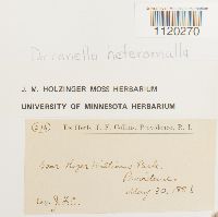 Dicranella heteromalla (Hedw.) Schimp. 641408[1120270]J.F. C. 2161886-05-30 United States, Rhode Island, Providence. Near Roger Williams Park |
MIN:Bryophytes | 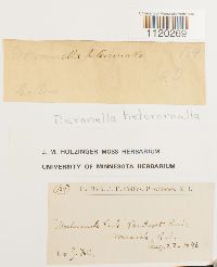 Dicranella heteromalla (Hedw.) Schimp. 641409[1120269]J.F. C. 1841886-08-22 United States, Rhode Island, Kent, "Morhassuck Park" Pawtucket River |
MIN:Bryophytes |  Ditrichum pallidum (Hedw.) Hampe 646537[1124872]J.F. Collins 1531886-06-20 United States, Rhode Island, Providence, Cat Swamp |
MIN:Bryophytes |  Ditrichum pallidum (Hedw.) Hampe 646540[1124873]J.F. Collins 1911886-06-20 United States, Rhode Island, Cat Swamp |
MIN:Bryophytes |  Grimmia olneyi Sull. 655511[1130734]Olney, S. T. 209 United States, Rhode Island |
MIN:Bryophytes |  Grimmia pilifera P. Beauv. 644256[1130696] s.n. United States, Rhode Island |
MIN:Bryophytes | 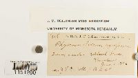 Physcomitrium pyriforme (Hedw.) Hampe 648183[1151200]Collins, J.F. 2231886-06-06 United States, Rhode Island, Adelaide Grove |
MIN:Bryophytes |  26978[1180457] United States, Rhode Island |
MIN:Bryophytes | 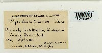 Polytrichum piliferum Hedw. [1298469]Harris, Stuart K. 29291936-04-04 United States, Rhode Island, Washington, South Kingston |
1
Page 1, records 1-10 of 10
Google Map
Google Maps is a web mapping service provided by Google that features a map that users can pan (by dragging the mouse) and zoom (by using the mouse wheel). Collection points are displayed as colored markers that when clicked on, displays the full information for that collection. When multiple species are queried (separated by semi-colons), different colored markers denote each individual species.